“the smart forestry of rome” – smart forestry as a function of air quality near road arteries. design of green filter spaces to counter pollution and reduce the amount of co2 present.
the air quality is significantly compromised by pollutants produced as a byproduct of the combustion of gasoline and diesel vehicles used for daily commuting, especially in proximity to road sections.
conducting monitoring near the most sensitive points to these pollution dynamics, especially during peak times, would allow us to create a data model for accurate quantification and typological selection of greenery as a direct countermeasure.
green, if well selected based on the context and integrated into a specific design perspective, can represent a form of smart remedy to human behavior that is less respectful of the environment. creating one or more filter spaces between the polluting source and areas for human activities (recreational, residential, productive, directional) would allow isolating the problem and counteracting it through nature integrations, measured according to needs.
furthermore, if designed on a larger urban scale, it can encourage strategies and interventions aimed at improving the quality of neighborhood’s collective spaces and urban mobility.
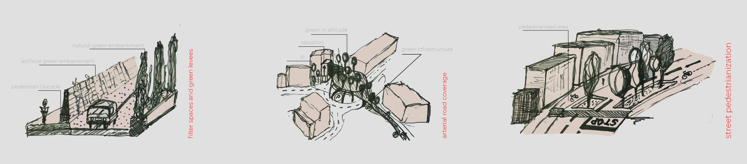
system sketches from the proposal
in summary, the macro objective of the project is to make the neighborhood or city behave based on human inputs; in terms of performance regarding air quality and housing comfort, in relation to the proposed urban solutions. “smart forestry of rome” intervenes, therefore, in the intelligent containment and disposal of pollutants (co-pm10-pm2.5) and the reduction of co2 in the air, through strategic design approaches of smart afforestation.
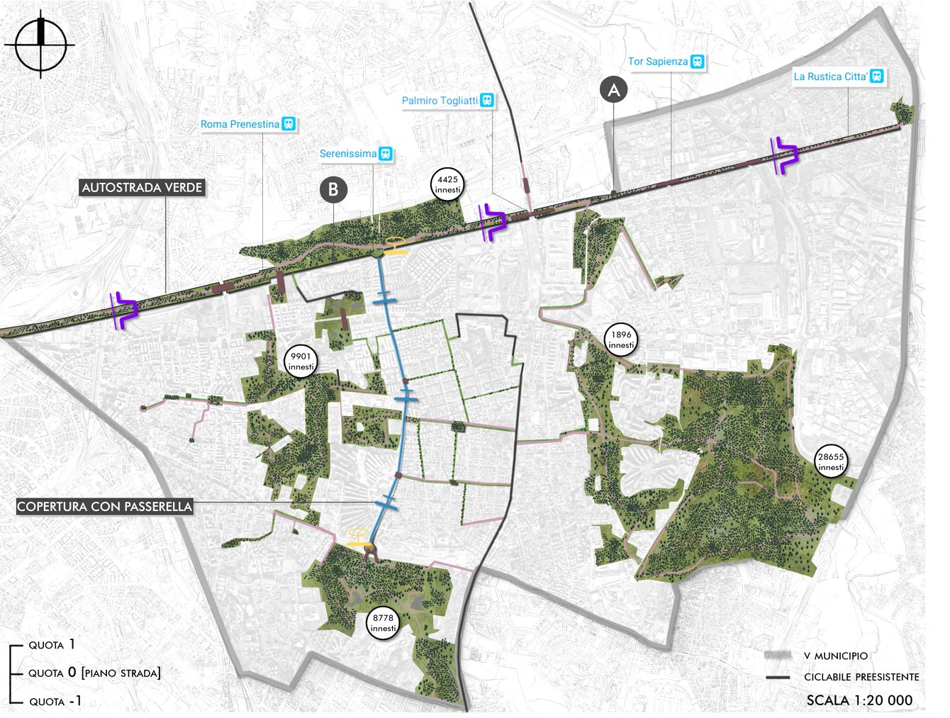
masterplan proposal
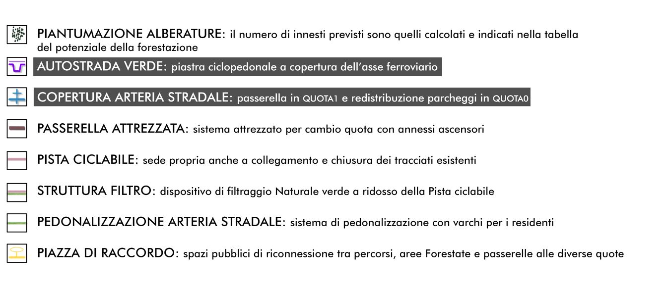
legend
perimeter definition of the zone
the v municipality of rome represents the perfect “test bench” to apply a performance recipe. it is crossed by four of the most trafficked road arteries in the capital [ a24 – a90 – via cassia – via casilina ] and is among the protagonists of the worst performances in terms of daily emissions, measured by the arpa lazio authority. furthermore, through the use of greenery, along with the aforementioned mission, it is possible to reclaim degraded areas, of which the v municipality is particularly abundant.
the identified area could serve as a virtuous example of intervention to be extended to neighboring areas in a second instance, in an expansive policy aimed at reconnecting nearby neighborhoods.
the project “smart forestry of rome” has 7 main objectives around which the entire process will revolve, and for which financial funding is requested from the u.i.a. (urban innovative actions) grant
- installation of monitoring stations for measuring pollutants near the selected artery or arteries, identified according to a specific study;
- publication of the measurement results, through which new “behavioral” evidence of pollutant trends in the road section can be identified;
- data collection campaign related to the green heritage of the delimited area;
- creation of the gis model, which will collect annotated information and systematize it [green animus: awareness of the health status of the greenery and its potential in terms of reducing co2 and pollutants from various emission sources;
- drafting of a new urban planning masterplan, which applies the changes dictated by the considerations arising from the study phase and respects the indications of the general master plan of rome;
- implementation of green integrations identified based on the data from the measurement campaign;
- creation of one or more typical road sections, designed with the aim of containing pollutants and their intelligent disposal.
the project in numbers of the v municipality of rome
- 27 sq km municipality extension
- 247,302 inhabitants
- 137 green areas
- 2,278,607 sq m of green space
- 8,832 trees along roadsides
expected results
- creation of a model for the specific tracking of pollutants near the identified road section;
- creation of an informational GIS model “green animus” for collecting and managing information about the existing greenery, especially in areas near the road arteries of Municipality V;
- drafting of an urban planning masterplan based on the choices dictated by the measurement campaign;
- implementation of urban afforestation integrations identified in the project guidelines;
- implementation of one or more proposed design solutions on typical road sections.